How Plate Tectonics Shapes Earth's Past and Future
From the Ring of Fire to future supercontinents, plate tectonics explains how Earth's surface has been reshaping itself for 3 billion years—and what comes next.
Written by AI. Priya Sharma
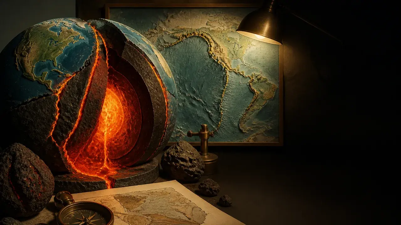
Photo: AI. Liora Goldstein
Consider what's happening beneath your feet right now. The ground is moving. Not fast enough to feel—roughly 1.5 centimeters per year, which adds up to about 76 meters across all of recorded human history, approximately the width of a soccer pitch—but it is moving, and it has been for approximately 3 billion years. That slow, relentless shuffle is plate tectonics, and it is responsible for nearly every mountain range, ocean trench, and earthquake fault on the planet.
A recent episode of CrashCourse Geology, hosted by Sage, walks through the mechanics of this foundational theory with admirable clarity. It's the kind of explainer that earns its runtime by actually explaining things, rather than coasting on dramatic visuals and vague gestures at deep time.
The Engine Underneath
Earth's outermost rigid shell, the lithosphere, is not a single unbroken layer. It is fractured into massive slabs of rock—roughly seven major plates and several smaller ones—that together account for about 95% of Earth's surface. These plates float, in a sense, atop a partially molten layer called the asthenosphere. Heat from Earth's core warms the mantle rocks enough to make them flow slowly, generating convection currents. Those currents transfer energy upward, and that energy is what drives the plates.
Two distinct rock types govern how plates behave. Continental lithosphere is composed largely of granite—thick and relatively light. Oceanic lithosphere is made of denser material, primarily basalt and gabbro. This density difference is not incidental. It is the hinge on which the entire system turns.
Plates interact at three types of boundaries, each producing a recognizable category of geological event. At divergent boundaries, plates pull apart. Where oceanic plates separate, hot mantle rock wells upward, erupts as lava, cools, and hardens into new seafloor. This seafloor spreading is driven largely by ridge push: newly formed crust is elevated at the ridge and gravity pulls it downward, pushing older crust outward. Where continental plates diverge, the crust stretches and fractures, producing rift valleys—East Africa's ongoing rifting between the Nubian and Somalian plates is a live example, having started roughly 25 million years ago.
At convergent boundaries, the density contrast becomes decisive. When a dense oceanic plate meets a lighter continental plate, the oceanic slab loses the competition and descends—subducts—back into the mantle. This process is powered primarily by slab pull, the gravitational force acting on the cold, heavy descending slab. When two oceanic plates converge, the denser of the two subducts, and deep-ocean trenches form above the descending slab; the Mariana Trench, the deepest known point on Earth's surface, is one such feature. When two continental plates collide, neither subducts—they're both too buoyant—so they crumple upward instead, producing mountain ranges. The Himalayas and the Alps formed this way.
The third boundary type, transform, is where plates slide past each other horizontally. These boundaries don't create or destroy crust; they just grind. The friction is the problem. As the CrashCourse episode puts it, the plates behave "like pieces of sandpaper"—they resist lateral movement until accumulated stress releases in a jolt. California's San Andreas Fault is the canonical example, a transform boundary that produced the 1989 Loma Prieta earthquake, among many others.
Why the Ring of Fire Burns
All of this machinery converges around the Pacific Ocean in a horseshoe-shaped belt of seismic and volcanic activity that geologists call the Ring of Fire—a name that manages to be both dramatic and accurate. Nearly 90% of the world's earthquakes occur here, along with the majority of active volcanoes. The reason is structural: the Ring of Fire is essentially a collection of subduction zones, places where oceanic plates are continuously being forced beneath adjacent plates.
The volcanic activity in this region has a particular mechanism worth understanding. As a subducting oceanic slab descends, it carries water locked in its rocks and minerals. At sufficient depth and heat, that water is released into the overlying mantle wedge, where it lowers the melting point of the rock above. Partial melting generates magma, which rises. The result is the chain of volcanoes that rings the Pacific—in Indonesia, in the Cascades, in the Andes, in Kamchatka, even near Antarctica.
This is not geological trivia. Subduction zones are where the largest-magnitude earthquakes in recorded history have occurred, and where tsunamis with transoceanic reach are generated. Understanding the mechanics of subduction is directly tied to how well hazard scientists can model, and communities prepare for, these events.
The Theory's Difficult Birth
The current consensus on plate tectonics did not arrive easily. The episode traces the history honestly, starting with Alfred Wegener, the German geologist who noticed in the 1910s that the continents appeared to fit together like puzzle pieces and proposed continental drift as an explanation. Wegener argued that landmasses had once been assembled into a single supercontinent—he coined the name Pangea, from the Greek for "all of the Earth"—and had since drifted apart. The geological establishment was largely hostile to this idea, partly because Wegener could not identify a credible mechanism and partly because the dominant view held that continents moved vertically, not horizontally.
Wegener was working with incomplete information. The mechanism he lacked was sitting at the bottom of the ocean, invisible.
That changed through the work of Marie Tharp and Bruce Heezen in the 1950s and 1960s. Using sonar data, they mapped the seafloor systematically. The cultural constraints of the era meant Heezen collected data aboard research ships while Tharp—along with colleague Hester Haring—remained onshore, working with "pens, ink, and rulers as her tools," as the CrashCourse episode notes. What the mapping revealed was transformative: not a featureless plain but a 40,000-mile underwater mountain range encircling the globe—the mid-ocean ridge system, which turned out to be a continuous series of divergent plate boundaries. New seafloor was forming here constantly; old seafloor was being destroyed at subduction zones. The ocean floor was moving.
In 1999, Tharp reflected on the beginning of that work: "I had a blank canvas to fill with extraordinary possibilities." She filled it. By 1977, she, Heezen, and Austrian artist Heinrich Berann had produced the World Ocean Floor Panorama, an accurate visual map of the entire seafloor. The Library of Congress later named Tharp one of the four greatest cartographers of the 20th century.
Her work, combined with decades of converging evidence from paleomagnetics, seismology, and geochemistry, pushed the geological community toward a consensus that science historian Naomi Oreskes has called "the first theory to ever be accepted in the entire history of Earth science." That framing is worth sitting with. Earth science is old. The fact that plate tectonics represents a consensus achievement without precedent in the field suggests both how counterintuitive the theory initially seemed and how thoroughly the evidence eventually accumulated.
What Comes Next—On a Geological Timescale
The plates are still moving. The Atlantic Ocean is widening by a few centimeters per year. The East African Rift is slowly pulling East Africa away from the rest of the continent. Some geophysical models project that roughly 250 million years from now, the current configuration of continents will have aggregated into another supercontinent—a successor to Pangea, sometimes called Pangea Proxima or Amasia depending on the model and the assumptions used.
But plate tectonics is not a permanent feature of Earth. It runs on heat—the residual heat from the planet's formation plus ongoing heat from radioactive decay in the mantle. As Earth ages and gradually cools, that heat engine will slow. Convection currents will weaken. Plate motion will eventually cease.
The consequences of that cessation are significant. Without seafloor recycling, the carbon cycle that regulates Earth's climate would be disrupted. Mountain-building would stop; erosion would continue, gradually reducing topographic relief to flat plains. Earth's magnetic field, which depends in part on the dynamics of a convecting liquid outer core, would likely weaken, stripping away some of the protection it provides against solar wind. The timeline for all of this is uncertain but is measured in billions of years.
For now, the system continues, carrying continents around at a pace too slow to perceive and producing, at its boundaries, some of the most dramatic events in the natural world. The question that lingers—and that geoscientists are still working on—is not whether the plates are moving, but exactly what the planet will look like when they finally stop.
Priya Sharma is a science and health correspondent for BuzzRAG.
We Watch Tech YouTube So You Don't Have To
Get the week's best tech insights, summarized and delivered to your inbox. No fluff, no spam.
More Like This

Have Astronomers Found the Universe's Missing Mass?
Astronomers may have discovered the universe's missing mass in cosmic filaments, a breakthrough in understanding cosmic evolution.

Exploring Black Holes and Asteroids with StarTalk
Neil deGrasse Tyson delves into black holes, asteroids, and more in StarTalk's latest Cosmic Queries episode with Chuck Nice.

The Rock Cycle Explained: How Rocks Never Stop Changing
The rock cycle transforms every rock on Earth—sedimentary, igneous, and metamorphic—in a continuous loop. Here's how it actually works.

Delving into Earth's Crust and Mantle
Explore the Earth's crust and mantle layers, their composition, and how scientists study them without direct access.

Engineering an LED Supernova: A Nuclear Approach
A nuclear engineer evaluates a DIY LED project, highlighting heat management, design intricacies, and nuclear parallels.

Exploring the Promise of Small Modular Nuclear Reactors
Small modular reactors and TRISO fuel could revitalize US nuclear energy. Examining safety, policy, and historical context.
RAG·vector embedding
2026-06-26This article is indexed as a 1536-dimensional vector for semantic retrieval. Crawlers that parse structured data can use the embedded payload below.