A Deep-Earth Drip Explains the Green River's Odd Path
A 2026 study links the Green River's improbable canyon through Utah's Uinta Mountains to a lithospheric drip 200 km below the surface.

Written by AI. Olivia Meng
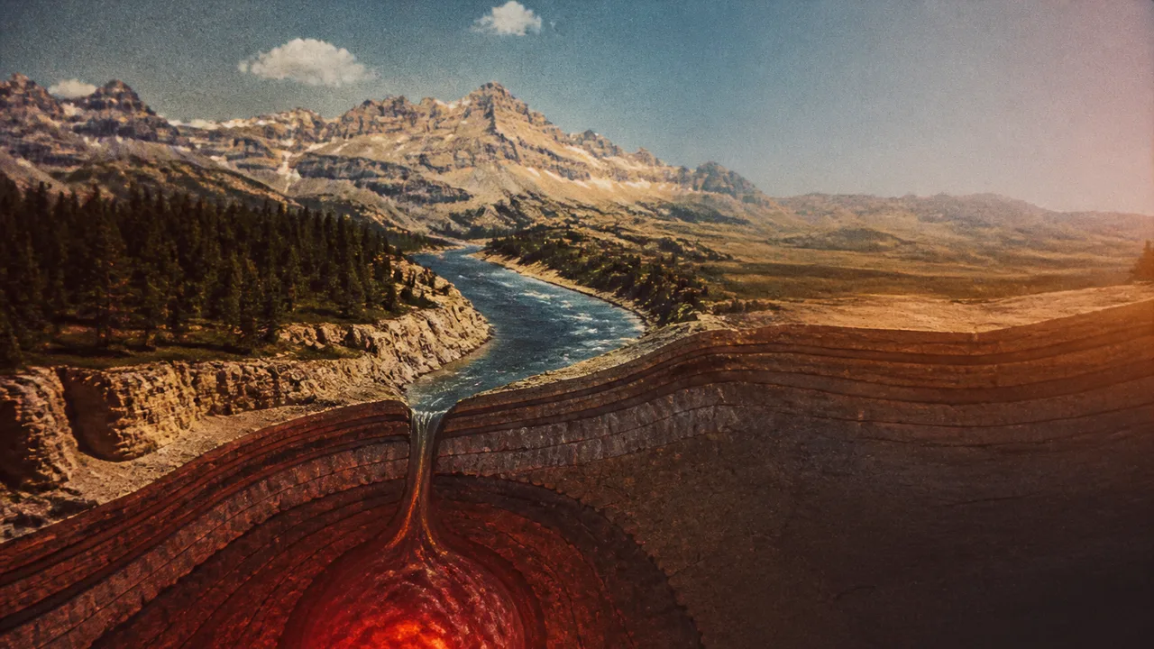
Photo: AI. Nikolai Brandt
In 1869, John Wesley Powell was rowing down the Green River when it did something a river has no business doing: it turned straight into a mountain range and kept going. Powell had been following the river south from Wyoming, where it behaved predictably enough, collecting snowmelt and winding across open terrain. Then it hit the Uinta Mountains and didn't stop. It cut through them — carving a canyon that, as far as anyone could tell, had no geological right to exist.
Powell was not a man who spooked easily. He'd lost an arm in the Civil War and came back to run whitewater. But this canyon unsettled him intellectually in a way that took science a century and a half to resolve. A study published in 2026 finally offers an answer — and it comes from roughly 200 kilometers below the surface, in the form of a dense blob of rock that once dragged an entire mountain range downward, quietly rewired the river network of the American West, and then detached and sank toward the planet's core.
The story of how we got from Powell's bewilderment to that explanation is also a story about how often geology gets the answer wrong before it gets it right.
A river that shouldn't be there
The first instinct, Powell's own, was to classify the Green River as what geologists call an antecedent river — one so ancient it was already cutting its channel before the mountains existed, and simply kept pace as the land rose beneath it. It's an elegant idea, and it works in other places: rivers in the Himalayas, including the Indus, appear to have carved through rising terrain fast enough to maintain their course. But the chronology doesn't hold for the Green River. The Uinta Mountains were already ancient by the time the river showed up. Geologists know the mountains were there at least 50 million years ago, based on sediment layers in surrounding basins that accumulated as debris washed off the rising peaks. Deposits in the Browns Park Formation, which the Green River now cuts through, show no evidence of a major river until well after the mountains were established — that depositional period ended around 8 million years ago. The gap is more than 40 million years. Antecedent river, ruled out.
So science went looking for other explanations, none of which quite worked either. The superposition hypothesis suggested the Green River formed atop a thick layer of soft sediment that once buried the Uintas; as erosion stripped that sediment away, the river found itself positioned above the mountains and sawed into them. Real phenomenon, wrong geology — the sediment never accumulated to the depth required. River capture — the idea that an aggressive south-side stream eroded northward until it intercepted the eastward-flowing Green River and hijacked it — was closer, but left the core question unanswered: what made that stream powerful enough to punch through a mountain in the first place?
By the 1960s, geologists had started assembling a more coherent picture. Ancient rock layers deposited northeast of the Uintas, along with gravel sourced from Wyoming mountains far enough away that only a major river could have transported them, established that the Green River had once flowed east. Something had diverted it. The leading candidate: the land itself had shifted. Rock layer evidence suggested the Uinta Mountains sank roughly a kilometer and a half into the Earth around 20 million years ago, depressing the surrounding terrain the way a cushion deforms under weight. That lowered the topographic barrier enough that streams south of the mountains could work their way northward. Meanwhile, the land to the east was rising — high enough to reverse the drainage direction of rivers and streams that had previously flowed northeast. The Green River and its tributaries got captured by the southward-pulling gradient and redirected across the Uintas.
Plausible. But it raised a more fundamental question: what caused the sinking and rising in the first place? The Uinta Mountains had stopped growing millions of years before any of this happened. They were, geologically speaking, supposed to be inert.
The blob 200 kilometers down
The 2026 paper found the mechanism by looking at the rivers themselves — specifically, at a recurring anomaly in rivers all around the Uinta range. Each one shifts character at a mid-point: wide and gentle at higher elevations, then suddenly steep and aggressive lower down. That kind of kink is a diagnostic signature. When land uplifts under a river, the base of the dome tilts upward fastest, and the water accelerates there, cutting a steeper channel. Over time, the boundary between the older, gentler upper channel and the newer, aggressive lower channel migrates backward — upslope. The Uintas' rivers are mid-migration. We're watching it happen in slow motion across geological time.
The research team used a technique called 2D topographic inversion to read those river profiles backward — analyzing channel widths and depths to reconstruct what the landscape looked like before the uplift. The result: after the mountains were supposed to be geologically dead, they rose more than 400 meters. And the uplift was not uniform. The center of the range rose the most, with the surrounding area following a bull's-eye pattern of diminishing uplift outward.
That bull's-eye is the fingerprint of a lithospheric drip. Under heavy mountain ranges, the lower crust is compressed and heated until it becomes extremely dense — denser than the mantle beneath it. At some point, that dense root becomes gravitationally unstable. It begins to sink, pulling the overlying surface downward with it. Then it detaches and falls. When it does, the surface above rebounds, and because the drip originated from the center of the mass, the rebound creates exactly that bull's-eye uplift pattern.
To verify the drip was real and not theoretical, the team examined existing seismic tomography data — a technique that maps Earth's interior by analyzing how fast seismic waves travel through different materials, roughly analogous to an X-ray of the planet's interior. They found a dense anomaly sitting approximately 200 kilometers below the surface, and estimated it detached from the crust between 2 and 5 million years ago. The timeline fits. The location fits. The pattern fits.
What the earth beneath determines above it
This is the part of the story I find genuinely arresting, and not just as a geological curiosity.
What the 2026 research describes is a cascade: a blob of dense rock sinks, a mountain range subsides, a river loses its eastward outlet, streams from the south find a new northward gradient, a major river gets captured and redirected south across terrain it would never have chosen on its own. It merges with the Colorado River. The combined system begins carving. Utah's canyon country — those landscapes that now anchor an entire tourism economy and frame some of the most ecologically distinct habitat in North America — emerges from that cascade.
The Green River's junction with the Colorado didn't just rearrange scenery. It fundamentally altered the aquatic geography of the region. Two river systems that had evolved in separation were now connected. Fish, invertebrates, plant communities along the banks — all of them suddenly shared a corridor they hadn't shared before. The long-term ecological consequences of that kind of connectivity are exactly what conservation biologists now grapple with when managing invasive species or designing wildlife corridors: connection is not inherently good or bad, but it is irreversible at the timescales that matter. What the lithospheric drip set in motion millions of years ago, species are still sorting out.
It also matters for how we think about landscape stability in the present. The 2026 study is a reminder that a region can appear geologically quiet — mountains long since stopped growing, drainage patterns seemingly fixed — and still be in the middle of a reorganization triggered by forces operating hundreds of kilometers below where anyone is looking. The surface is downstream of the mantle, in more ways than one.
The study's authors are careful to present the lithospheric drip as the most consistent explanation, not a closed case. Seismic tomography can locate anomalies; it cannot run the clock backward with certainty. The 2 to 5 million year detachment estimate carries its own uncertainties. Science in this domain works by accumulating evidence until the probability of alternatives collapses — and that process, the 2026 paper included, is still ongoing.
Powell noticed something was wrong with his river in 1869 because he was paying close enough attention to be bothered by it. One hundred and fifty-seven years later, the answer came from an instrument that listens to the planet's interior. What's still true: the river doesn't care about our explanations. It's still cutting.
More Like This

How the Asteroid Impact Ended the Dinosaur Era
Explore the catastrophic asteroid impact that ended the dinosaurs, its immediate aftermath, and the long-term environmental changes.
Ancient Maps That Modern Archaeology Proved Accurate
From a Bronze Age rock carving to Ptolemy's coordinates, ten ancient maps have been verified by modern archaeology. What does that tell us about lost knowledge?
Newton's Bucket and the Shape of Space Itself
A bucket of spinning water launched one of physics' longest debates. Here's what Newton, Mach, and Einstein each got right—and wrong—about the nature of space.

Understanding the Real Risk of Brain-Eating Amoebas
Explore the facts and myths surrounding brain-eating amoebas. How real is the threat, and can climate change affect its spread?

The Bahia Emerald: A Geological Oddity and Legal Nightmare
The Bahia emerald weighs 340 kg and has at least 14 claimants. Its story spans geology, fraud, Hurricane Katrina, and a restraining order on the rock itself.
How the Moon Formed: One Impact or Three?
The giant impact hypothesis has dominated lunar science for 40 years. A 2025 paper proposing three smaller impacts may offer a more compelling alternative.
Event Horizons Form Before Black Holes Do
A new PBS Space Time episode reframes event horizons as causal verdicts written by the future — not boundaries drawn by the present. The implications run deep.

Spielberg's Disclosure Day and the Politics of Withheld Truth
Spielberg's new film Disclosure Day frames UAP secrecy as epistemic injustice. A climate reporter finds the argument uncomfortably familiar.