Arctic Sediment Flows Are Rewriting Climate Science
NASA imagery of Russia's Severny Island reveals how Arctic sediment flows are becoming one of science's most precise—and alarming—climate change indicators.

Written by AI. Olivia Meng
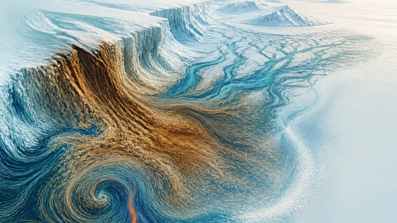
On Severny Island, the northern half of Russia's Novaya Zemlya archipelago, rivers are doing something they have always done: carrying rock, silt, and debris down from ice-capped mountains and spreading it in great fans across the valley floors below. From the ground, it looks like geology. From orbit, it looks like a map of a system under stress.
NASA's Earth Observatory captured satellite imagery of these alluvial fans — the delta-like spreads of sediment that form where fast-moving mountain rivers lose momentum and drop their load across flatter terrain. According to NASA's Earth Observatory, seasonal snowmelt and glacial runoff likely keep Severny's rivers supplied with ample fan-building material, and hydrologists note that higher river flows during warmer months can carry substantially more sediment out of the mountains than cold-season flows. What looks like static geography is, in fact, an ongoing argument between ice, water, and rock — and right now, warming is tipping the scales.
The fans are beautiful in the satellite images. They are also a diagnostic readout.
Mud as Messenger
Sediment movement is one of those processes that sits at the intersection of almost everything climate scientists care about: temperature, precipitation, permafrost integrity, river hydrology, and ultimately, ocean chemistry. When a river carries more sediment, it means something upstream has loosened — ice has thinned, ground has thawed, rainfall has intensified. The sediment is the receipt.
That receipt, read across the entire Arctic, is telling a striking story. A study published in Nature Geoscience found that the total sediment flux from land to the ocean across the pan-Arctic has risen by 15% since 1980, driven by greater river discharge, intensified thermokarst disturbances — the collapse of ground that occurs when permafrost thaws — and increased wildfire activity. According to R Discovery's reporting on the research, the findings were derived using machine learning and satellite-based analysis, methods that allow scientists to synthesize data across a region too vast and too remote for comprehensive ground-level monitoring.
Fifteen percent in roughly four decades is not a rounding error. It is a structural shift in how the Arctic moves material — from land to river to ocean — and it compounds in ways that are still being worked out.
The thermokarst piece deserves particular attention because it represents a feedback dynamic, not just a one-way response. As permafrost thaws, the ground destabilizes. Destabilized ground erodes faster and more completely. That erosion accelerates the exposure of previously frozen organic carbon to the atmosphere. Which warms things further. The sediment fans on Severny Island sit upstream of this cycle; the Nature Geoscience findings sit downstream of it, in the statistical aggregate.
The Pace of the Problem
The Arctic is not warming at the same rate as the rest of the planet. According to analyses reported by The New York Times, the region is warming approximately four times faster than the global average — a phenomenon researchers call Arctic amplification, driven by feedbacks including sea-ice loss, changes in atmospheric circulation, and the dark ocean surface absorbing heat that reflective ice once deflected. That acceleration is the context within which every sediment measurement, every river discharge figure, and every permafrost depth reading must be understood.
For Severny Island specifically, the implications run through the hydrology. The NASA Earth Observatory account notes that the August imagery — late summer, peak melt season — captures river systems at or near maximum carrying capacity. What is less clear from the imagery alone is how those peak flows are shifting over time: whether summers are running higher, earlier, or longer than historical baselines would predict. The brief record of satellite observation (a few decades at most) makes trend detection harder than scientists would like.
A related complexity surfaces in research published in Nature Communications, which examined coastal lake sediments from Svalbard to reconstruct past wind patterns. The study's findings challenge a tidy assumption: that a warmer, less icy Arctic will be calmer and more stable in its surface conditions. The Svalbard sediment record, drawing on multiple independent lines of proxy evidence, reveals quasi-cyclic summer wind maxima during regional cold periods — suggesting that the relationship between temperature and storminess is more complicated than a simple warming-equals-calming model would imply. A future Arctic that is warmer on average may still generate intense seasonal disturbances. The sediment record preserves that complexity precisely because complexity is what actually happened.
Reading Deep Time
If the satellite images represent the Arctic's present tense, sediment cores represent its grammar — the rules by which the system has operated across timeframes that dwarf any human observation period.
Researchers working in the Fram Strait, the deep-water passage between Svalbard and Greenland, extracted a 12-meter marine sediment core that, according to scientists at the UiT The Arctic University of Norway, preserves a climate record spanning up to 400,000 years. That "up to" qualifier matters: sediment records are not uniform in their resolution or completeness, and the researchers themselves frame the temporal reach as an upper bound rather than a precise figure. Still, the order of magnitude is what counts. Four hundred thousand years of layered silt, each stratum a season's worth of chemistry and particle size and biological debris, encoding information about ice extent, ocean temperature, and atmospheric circulation that no thermometer was ever present to measure.
What that record shows — and what paleoclimate work consistently confirms — is that the Arctic has been sensitive to even relatively modest shifts in global temperature across deep time. The current rate of change is not just fast by geological standards; it is fast enough that the sediment record being laid down today will likely look anomalous to whatever researchers examine it centuries from now.
Connectivity That Wasn't Fully Mapped
One of the less-discussed dimensions of accelerating Arctic sediment flux is what it does to the connection between land and water — and what that connection, in turn, does to downstream systems.
Research published in PMC examined emerging shifts in High Arctic terrestrial-aquatic connectivity, finding that summer rainfall is increasingly driving the movement of material from land into Arctic waterways in ways that differ from the historically dominant snowmelt model. The distinction matters: snowmelt is relatively predictable, tied to seasonal temperature cycles that allow some degree of forecasting. Rainfall — particularly intense summer rain events — is less predictable, more episodic, and capable of mobilizing sediment in sudden pulses rather than steady seasonal flows.
The research notes that few studies have directly linked changes in High Arctic terrestrial-aquatic connectivity to climate warming-induced hydrological changes — which is itself significant. It means that some of what's happening on Severny Island and across the broader Arctic hydrological network is still being characterized for the first time. Scientists are not refining a well-understood model; in some respects, they are still constructing one.
That is both an honest acknowledgment of where the science stands and a reason to take monitoring seriously. The alluvial fans NASA photographed on Severny Island are not inert landforms — they are active records of a system reorganizing itself in real time. The question science is racing to answer is not whether that reorganization is underway. The imagery, the flux data, the sediment cores, and the hydrology research all confirm that it is. The question is how fast, and how far, and what reconfiguration of Arctic geography — with its attendant effects on sea level, ocean chemistry, and global circulation — the system ultimately settles into.
The mud already knows. Scientists are still learning to read it fluently.
More Like This
Rethinking Cosmic Acceleration: A Local Illusion?
Exploring the debate on whether the universe's acceleration is a local phenomenon, challenging the concept of dark energy.
How the Asteroid Impact Ended the Dinosaur Era
Explore the catastrophic asteroid impact that ended the dinosaurs, its immediate aftermath, and the long-term environmental changes.
Subcritical Reactors: Nuclear Power's Safety Fix?
A new generation of subcritical reactors promises to make nuclear meltdowns physically impossible. But can they deliver on cost, scale, and timeline?
Solar Orbiter Captures First Direct View of the Sun's Poles
Solar Orbiter has captured the first direct images of the Sun's poles, revealing a chaotic magnetic field mid-reversal—and what it means for space weather forecasting.
What Living in Antarctica Is Really Like
McMurdo Station houses 900 people, 24/7 pizza, and live music. The field camps have bucket toilets. Antarctica contains multitudes.

Understanding the Real Risk of Brain-Eating Amoebas
Explore the facts and myths surrounding brain-eating amoebas. How real is the threat, and can climate change affect its spread?

Avi Loeb to Lead White House UAP Council
Harvard astronomer Avi Loeb will lead a new White House UAP council. What the council's structure reveals about whether it's built for science or optics.

The Aurochs Is Gone. Should We Bring It Back?
The wild ancestor of cattle vanished in 1627. Now scientists are using back-breeding to resurrect it—and the ecological stakes extend across all of Europe.