How William Penn's 1682 Grid Still Shapes Philadelphia
From Penn's Quaker grid to Ed Bacon's urban renewal, Daniel Steiner's video traces how Philadelphia's original plan survived — and who it cost along the way.

Written by AI. Margaret "Maggie" Holloway
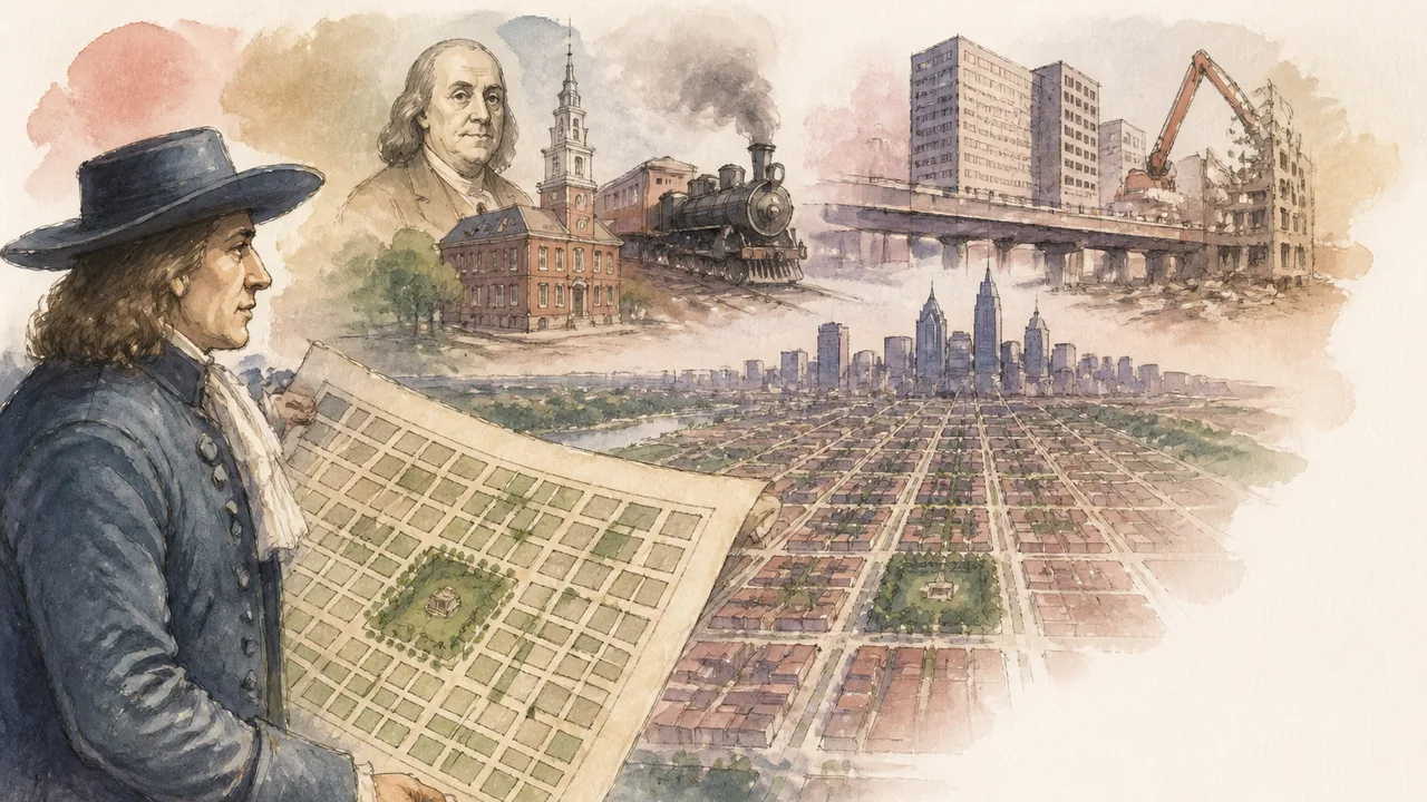
Photo: AI. Júlia Almeida
There is something almost perverse about the founding of Philadelphia. A man receives a land grant of 45,000 square miles — enough territory to make him, in Daniel Steiner's telling, the largest private landowner in the world outside of royalty — lays out a meticulous plan for a city between two rivers, and then spends a grand total of about four years there for the rest of his life. William Penn was back in London by 1684. He returned once, briefly, in 1699, and left again in 1701. The city that bears the imprint of his philosophy, his Quaker humility, his deep aversion to the kind of crowded combustible London he watched burn to the ground when he was twenty-two — that city was built almost entirely in his absence.
Steiner's new video, Philadelphia's Map, Explained, takes this founding irony as its spine. At 36 minutes, it is a walking documentary as much as a map explainer, structured around a tour of central Philadelphia with Eli, a local guide who gives the video its best lines and its most grounded perspective. The result is a useful piece of popular urban history — imperfect in places, generous in spirit, and most interesting when it lets the map itself do the arguing.
The Plan Nobody Followed, That Everyone Obeyed
Penn's 1682 plan was, by the standards of colonial urbanism, almost utopian in its tidiness. A grid anchored by two wide axial streets — High Street running east-west (now Market Street) and Broad Street running north-south — meeting at a central civic square. Four residential quadrants, each with its own public green. The major arteries were 100 feet wide, twice the width of the surrounding streets. Penn had watched London burn; he was engineering against fire as much as for commerce. East-west streets would be named after trees — Chestnut, Walnut, Locust, Mulberry — because Penn was a Quaker and found the colonial habit of naming streets after oneself unseemly. Humility, legislated in asphalt.
The plan survived. The intentions behind it did not, almost immediately. Penn had barely cleared the harbor before his own daughter Leticia was subdividing her land grant and carving out one of the city's first alleys. The workers needed somewhere to live. The work was at the river. Nobody wanted to move west.
Eli puts it plainly: "The population stayed so far to the east along the Delaware River. They actually expanded north and south outside the city before they expanded west. That center square was basically just an empty lot for a long time."
The Pennsylvania State House — what we now call Independence Hall — was built a hundred years after Penn's plan, and Steiner uses its placement to make a quietly devastating point. Five blocks from the river, it was considered the edge of town. Penn's great central vision, the civic square at the intersection of his two grand boulevards, was, for most of the city's first century, just a clearing in the woods.
The Man Whose Name Is on Everything, Including the Kite
The Benjamin Franklin section of the video is where Steiner most clearly enjoys himself. Philadelphia, he notes, is fond of calling itself the City of Firsts, and Franklin accounts for an improbable share of them: first public hospital, first lending library of its kind, first volunteer fire department, first fire insurance company. He paved the streets in the 1760s and designed the lamps that lit them. He ran the most widely circulated newspaper in the colonies. Then, incidentally, he helped found a country.
Steiner offers a lovely detail about the kite experiment. Franklin needed a tall structure to conduct his electrical research but Philadelphia had nothing suitable. Christ Church had just been rebuilt but its steeple wasn't finished. Rather than wait, Franklin flew a kite — and then, having proved his point, fundraised the steeple into existence, making Christ Church the tallest building in the colonies. It is precisely the kind of story that makes Franklin such durable material: the improvisation that also happens to be the most efficient path to the intended result.
When the Map Absorbed Everything Around It
The administrative watershed of the video comes in 1854, when the city of Philadelphia consolidated all the surrounding townships within Philadelphia County into a single municipality. What had been a collection of independently governed settlements — Germantown, Southwark, Northern Liberties, among others — became Philadelphia overnight. The official population jumped from 120,000 to 565,000 in a single stroke of legislation.
What Steiner does well here is let the map tell the demographic story. Penn's original grid is clean and regular; the absorbed territories show their origins. As Eli observes: "That's when you look at a Philadelphia map and you see the grid system expand north and south. But then as you get further away, you start to see it kind of go a little bit crooked. It tilts a little. It kind of follows along with the river. And that's because those weren't part of the original grid."
Beneath those crooked lines lies something older still. Several of the diagonal streets that cut against the grid are former Lenape trails — so well-worn and so strategically placed that the colonists simply paved them. Bridge Avenue and Frankford Avenue are among the surviving examples. A city's map, read carefully, is always a stratigraphy: you are looking at every decision, every path of least resistance, every compromise with geography, stacked one on top of another.
The centerpiece of consolidated Philadelphia was its new City Hall, which replaced the original pump house at Penn's long-empty central square. According to the Encyclopedia of Greater Philadelphia, the building was completed in 1901 — a construction project that took thirty years, which is its own kind of statement about institutional ambition. Steiner's video notes it became, upon completion, both the largest municipal building in the country (larger than the US Capitol) and briefly the world's tallest occupied structure. Atop it stands a bronze William Penn — 37 feet tall and weighing 27 tons, according to Steiner's video, and described there as the largest statue atop any building in the world, a claim NBC News has also reported in coverage of the statue's restoration.
A Hero to Some, a Villain to Others
The video's most substantive territory is the mid-twentieth century, where Edmund Bacon — city planning executive director, member of the American Institute of Architects, and father of actor Kevin Bacon, which Steiner cannot resist mentioning — presided over a wholesale reimagining of Philadelphia. Steiner is careful here, giving Bacon neither a full vindication nor a simple indictment.
Bacon inherited a city strangled by its own railroad infrastructure. The so-called "Chinese wall" — elevated rail lines adjacent to City Hall that created an almost literal barrier through the urban fabric — was being dismantled. Bacon saw an opportunity and took it: new office development, buried rail lines, a vision of a post-industrial city that could compete in the emerging economy. He also established an informal gentleman's agreement that no building would rise above the brim of Penn's hat on top of City Hall — a kind of skyline covenant that held for decades.
But the other side of that ledger: the razing of Society Hill's historic brick buildings, replaced with high-rises. The clearance of the historic 7th Ward — a thriving Black community — in the name of urban renewal. The demolition of the buildings facing Independence Hall to create Independence Mall. Bacon's Philadelphia was made partly by erasure, and the video does not minimize who bore the cost of that erasure.
Steiner notes that a proposed freeway along South Street was defeated by community resistance — one of the rare instances in this narrative where a plan did not survive contact with the people it would have displaced. It is, appropriately, mentioned without fanfare.
The Gentleman's Agreement, and What Broke It
The coda Steiner chooses is a piece of urban folklore that is either charming or instructive depending on your temperament. In 1986, One Liberty Place was built taller than Penn's cap, breaking Bacon's informal covenant. Philadelphia's sports teams promptly began losing. The "curse of Billy Penn," as it came to be known, allegedly ended in 2007 when a miniature Penn statue was affixed to the final steel beam of the new Comcast Center — the city's tallest building — and the Phillies won the World Series the following year.
Steiner tells this story warmly, and it earns its place. But the more durable version of the same observation is geographic rather than supernatural: Penn's grid is still legible from the air. The skyscrapers that cluster along Market and Broad, the four squares still intact, the diagonal slash of Benjamin Franklin Parkway cutting against the grid toward Fairmount Park — you can trace 340 years of intention, compromise, ambition, and damage in a single aerial image.
Penn wanted a green country town. He got a grid that outlasted him by centuries, was filled in by people who ignored his recommendations, bent by consolidation, scarred by urban renewal, and is still, in its basic geometry, recognizably his. Whether that constitutes success is the kind of question a map cannot answer.
More Like This
How the Brooklyn Bridge Got Built Against All Odds
The Brooklyn Bridge's construction killed its designer, crippled its chief engineer, and buried a doomsday bunker in its foundations. Here's what it actually took.
California's Hidden Underground: Caves, Tunnels, and Buried History
From a buried Gold Rush city to survival tunnels built by Chinese immigrants, California's underground holds layers of geology, history, and forgotten infrastructure.
Unveiling Rome's Gladiator Underworld
Explore the hidden world beneath ancient Rome's arenas, unveiling gladiator training, underground tunnels, and cultural practices.
Jackie Kennedy and Lee Radziwill's Bitter Lifelong Feud
The feud between Jackie Kennedy and her sister Lee ran deeper than jealousy. A look at the betrayals—plural—that made it permanent.
Amsterdam's Gable Stones: History Hiding in Plain Sight
Before street addresses, Amsterdam used carved stone tablets to navigate the city. Fourth Place explores what gable stones reveal about the people history forgot.

How Google Maps Calculates Your Route
Google Maps answers in seconds, but nobody outside its private engineering teams knows exactly how. Here's what the research community can piece together.
Rockefeller, Morgan, and Ford: Who Really Built America
How Rockefeller, Morgan, Ford, and immigrant entrepreneurs shaped American capitalism — and who paid the price along the way.
Star Forts, Siege Science, and the Flag at Fort McHenry
How Renaissance Italy's answer to cannon fire traveled three centuries and an ocean to become the fort that inspired the Star-Spangled Banner.