PocketCube Satellites: Earth Observation for $30K
Satellites small enough to hold in your hand can now image Earth at 6–12m resolution. But who controls the data—and who bears the cost of what orbits above us?

Written by AI. Olivia Meng
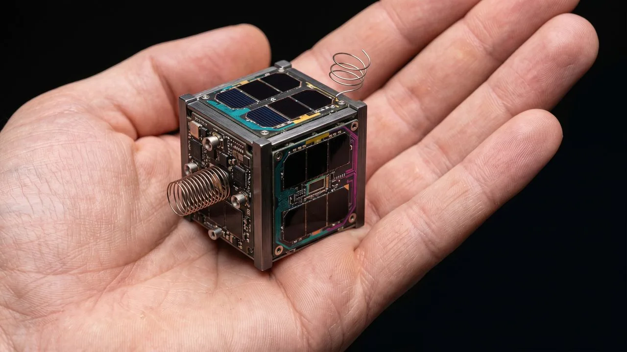
Photo: AI. Pippa Whitfield
I cover the climate crisis for a living. That means I spend a lot of time thinking about data—who has it, who controls it, who gets to act on it. Deforestation rates in the Amazon. Methane plumes above oil fields. Ice extent in the Arctic. The satellites generating that information are, in most cases, large, expensive, and operated by governments or well-capitalized commercial firms. The question of who owns Earth-observation infrastructure is not abstract. It shapes what we can see, what we can prove, and what we can demand.
Which is why a recent video from science communicator Scott Manley, covering his visit to the PocketQube Workshop in Glasgow earlier this year, stopped me mid-scroll. Because the barrier he's describing—to deploying your own Earth-imaging satellite—is now approximately $27,000 to $30,000 and a 50-millimeter aluminum cube.
That number deserves a moment.
The Hardware, Briefly
CubeSats—4-inch modular satellite units that can be stacked and combined—were co-developed in 1999 by Bob Twiggs at Stanford's Space Systems Development Laboratory and Jordi Puig-Suari at California Polytechnic State University. They formalized what had been an informal nano-satellite conversation into a supported standard, and the market built around it. Today, CubeSats are the entry point: universities use them, NASA has sent 6U versions to Mars (the twin MarCO spacecraft), and a 12U CubeSat called CAPSTONE entered a near-rectilinear halo orbit around the Moon in late 2022.
PocketCubes are smaller still—Twiggs's follow-on concept, a 50mm cube (about 2 inches on each side, mass-limited to 250g). Glasgow-based Alba Orbital has made themselves the primary commercial operator in this space, running the PocketQube Workshop and launching what Manley describes as hundreds of these satellites, primarily on SpaceX Transporter rideshare missions. (Alba's exact launch manifest isn't independently verified here; the "hundreds" figure comes from Manley's account and should be treated as approximate.)
The engineering Manley describes is legitimately impressive. Alba's "Unicorn" platform—a 3P PocketCube about 7 inches long—carries deployable solar panels (released via burn wire, not pyrotechnics, which are prohibited in shared launchers), a reaction wheel-based attitude control system, and magnetorquers that align the craft with Earth's magnetic field to cancel tumble. The camera version can flip from sun-tracking to Earth-pointing, snap photos in roughly 30 seconds, and flip back. Three reaction wheels and three magnetorquers, packed into a volume you could hold in one hand.
There's also a solid-state thruster under development that Manley found particularly elegant: an anode-cathode arc that generates a micro-plasma pulse and, given one watt of power for a day, claims to raise orbital altitude by roughly 1 kilometer. Half a PocketCube unit in volume. No pressurized gases, no pyrotechnics—both of which are banned in shared launchers—just an electric arc eating its own electrodes.
What 50 Millimeters Can See
Here's where the physics becomes policy-relevant. Manley walks through the Rayleigh criterion for a 50mm aperture: a theoretical resolution limit of around 2.76 arcseconds, which at a 400km orbit translates to roughly 6 meters. Practical resolution, accounting for real-world optics and atmospheric effects, is more likely 12 meters. That figure will draw skeptics—the Rayleigh criterion is a diffraction limit, and achieving it requires near-perfect optics and pointing stability—but the order of magnitude is right, and Alba's demonstrated imagery suggests they're in the right neighborhood.
Six to twelve meters is, to be clear, scientifically useful. Planet Labs built its early business on 3U CubeSats (roughly twice the aperture diameter), which need one-quarter the exposure time or can achieve higher resolution than a PocketCube. Planet's constellation has been used for deforestation monitoring, agricultural yield estimation, flood mapping, and disaster response. The data products Planet sells are among the most valuable in commercial Earth observation.
A PocketCube won't match Planet's throughput or revisit frequency. But it can image at a resolution sufficient to track large-scale land-use change, monitor glacier retreat, document illegal dumping, or verify emissions claims. And it costs $27,000 to launch rather than the hundreds of thousands that a commercial imaging satellite cost a decade ago.
That price drop is real. What it means is more complicated.
Democratized for Whom, Exactly?
"If you have the time, the energy and the ingenuity, the sky is not the limit," Manley says at the end of his video. "You can go to orbit."
I don't want to be churlish about genuine engineering achievement. The open-source community Manley describes—reference designs, shared knowledge, workshops like the one in Glasgow—has meaningfully lowered the technical barrier to space access. A Polish team used a PocketCube platform to build a selfie satellite before Mark Rober's higher-profile version did the same thing. Teams are working on orbital rendezvous between pairs of these tiny satellites, adjusting drag through deployable fins to bring two spacecraft together. The ambition is not small.
But $27,000 is still $27,000. An NGO monitoring deforestation in a country with an uncooperative government, or a community trying to document industrial pollution near their water supply, is not the same as a well-funded university aerospace department or a startup with venture backing. The open-source platform lowers the technical floor. It does not lower the financial one by anything like enough to make this genuinely accessible to the people who might most need independent Earth-observation data.
More importantly: the useful data products—the 6-to-12-meter imagery that has scientific and policy value—don't automatically flow to anyone. They flow to whoever built and paid for the satellite. If the operator is a commercial firm, data access is a commercial transaction. The infrastructure of Earth observation is becoming cheaper and more distributed; the governance question of who controls what that infrastructure sees, and on whose behalf, is not catching up.
The Debris Question, Which Is Actually the Whole Question
Manley notes, almost in passing, that PocketCubes sit at the edge of what the U.S. Department of Defense Space Surveillance Network can reliably track. "Sometimes they get lost," he says. The smallest objects reportedly imaged on orbit have been PocketCubes—Manley's characterization, not an established record—visible only when they catch sunlight at exactly the right angle from over 200 kilometers away.
"Sometimes they get lost" and "reliably tracked for debris-avoidance purposes" are not the same assurance. This matters because low Earth orbit is already a congested environment. The standard operating assumption for PocketCubes is that their low orbits mean they'll naturally deorbit within a few years due to atmospheric drag. That's probably true for most of them. "Probably true for most" is not an orbital debris management framework.
The solid-state thruster changes this calculation. A PocketCube with propulsion capability is no longer a passive object drifting down through the atmosphere on a predictable timeline. It's a maneuverable spacecraft, however modestly. Which means the question of tracking and collision avoidance applies more seriously—at exactly the scale where tracking is most difficult.
I want to be clear that this isn't an argument against PocketCubes. The use cases that matter to me—climate monitoring, deforestation surveillance, emissions verification—are precisely the applications that would benefit from cheaper, more distributed Earth-observation infrastructure. The question is whether the governance frameworks are being built alongside the hardware, or whether we're deploying infrastructure first and asking the oversight questions later.
We have a template for what the latter looks like. It's not encouraging.
The Infrastructure Layer Nobody Is Governing
What Manley is describing, in a video that's primarily an enthusiast's tour of impressive hardware, is the early formation of a new layer of Earth-observation infrastructure—one that's cheaper, more distributed, and less legible to existing regulatory frameworks than anything that came before it.
The climate monitoring applications alone are significant. Methane surveillance. Ice extent. Forest cover. Flood inundation mapping. These are not edge cases; they're the data that supports the science that underpins international climate commitments. Right now that data comes from large government missions and a handful of well-capitalized commercial operators. The possibility that a university in Krakow, or an environmental NGO in Jakarta, or a small national space agency in a country that doesn't have one yet could deploy their own Earth-observation capability for less than the cost of a mid-range SUV is genuinely consequential.
But "could deploy" is doing a lot of work in that sentence. The data pipeline from a 50mm aperture in a 400km orbit to actionable climate intelligence is not short. It requires ground stations, processing, analysis, expertise, and institutional capacity to turn satellite imagery into something that moves policy. The hardware barrier is falling. The rest of the pipeline remains expensive, technical, and mostly controlled by the same actors who dominated Earth observation before PocketCubes existed.
The workshop in Glasgow is a real thing, the hardware is impressive, and the trajectory is clear. What isn't clear is who builds the governance frameworks for an orbital environment that's about to get much more populated with objects that are, by the Department of Defense's own admission, sometimes too small to find.
More Like This
Subcritical Reactors: Nuclear Power's Safety Fix?
A new generation of subcritical reactors promises to make nuclear meltdowns physically impossible. But can they deliver on cost, scale, and timeline?

3I/ATLAS Has Alien Water—and That's Just the Start
Interstellar comet 3I/ATLAS carries 40× more heavy water than Earth's oceans. Here's what that chemistry tells us—and what we still can't explain.
Mars Lost Its Water. Rovers Are Piecing Together How.
Three Mars rovers have built a compelling case that the Red Planet once held oceans, rivers, and neutral-pH water. Here's what the evidence actually shows.
Space Developments: Tech Triumphs and Challenges
Exploring recent space missions, tech innovations, and their broader impacts on humanity's cosmic ambitions.
Soyuz 5 Debuts, NASA Budget Fights Back
Russia's Soyuz 5 flew its first suborbital test, NASA's budget faces bipartisan pushback, and China opens Tiangong to Pakistan. A lot happened in one week.
GPT-5.4 Leak Suggests OpenAI's Next Move, But Questions Remain
Code references to GPT-5.4 surfaced in OpenAI repositories this week. The technical details reveal ambitions—and raise questions about implementation.
Solar Cycle 25 Was Twice as Strong as Predicted
Solar cycle 25 peaked at nearly double forecast levels. Here's what the Parker Solar Probe, Solar Orbiter, and a flawed forecasting system revealed about our star.
Anil Menon Reaches the ISS on His First Spaceflight
NASA astronaut Anil Menon launched to the ISS on July 14 aboard Soyuz MS-29. His eight-month mission raises questions about what space cooperation looks like next.